

A few hours of preparation can make a big difference
For those of us who live and work in the low-lying areas along the Columbia River, the local levees do a lot to reduce the risk of flooding. But no levee can ever provide 100% protection, which means it’s up to each of us to be prepared for a flood. A few hours spent making your home or place of business secure, preparing an emergency kit, and creating a flood plan can make a big difference. Here are some resources to help you prepare before a flood.
Make a Plan
Flooding is the most common natural disaster in the United States and can happen anywhere. You can create an emergency plan for flooding, and other emergencies, in just three steps:
- With your family or household members, discuss how to prepare and respond to the types of emergencies that are most likely to happen where you live, work and play.
- Identify responsibilities for each member of your household and how you will work together as a team.
- Practice, practice, practice.
Resources
Ready.org: Plan ahead
American Red Cross: Create and practice an emergency plan
Be 2 Weeks Ready Toolkit
FEMA Video: Preparing Makes Sense
Build a supply kit
In an emergency, emergency response teams may not be able to assist everyone immediately. Being prepared means being equipped with the proper supplies you may need in the event of an emergency or disaster. Keep your supplies in an easy-to-carry emergency preparedness kit that you can use at home or take with you in case you must evacuate.
Resources
American Red Cross: Survival kit list
FEMA: Build a Kit
Multnomah County Emergency Management: Family emergencies supplies calendar
PBEM’s budget friendly shopping list
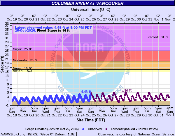
Current River Conditions
Vancouver Gauge – National Weather Service
UFSWQD Flood Categories
During high water and heavy rain events, the District implements emergency action plans to keep levees and facilities functioning to protect life, property, and the environment. UFSWQD uses the National Weather Service (NWS) Vancouver Gage on the Columbia River to make flood emergency related decisions.
Our emergency response categories are divided into four levels:


SIGN UP FOR PUBLIC ALERTS
Emergency Alerts to Keep You Safe
UFSWQD Flood Emergency Action Plan (FEAP)
Our response to a flood event is described in detail in our Flood Emergency Action Plan (FEAP).The plan outlines the District’s response to the threat of a flood. This plan only addresses emergency response to a flood event on the Columbia River or Lower Columbia Slough; it does not cover response to stormwater emergencies.
Trainings and Exercises
District employees undergo Federal Emergency Management Agency (FEMA) trainings in order to prepare for our role in a flood or other regional emergencies. We put our plans to practice and hold annual tabletop exercises with partners to ensure a coordinated approach to emergency response.
Evacuations
Though the District isa first responder in a flood event, the organization of an evacuation and the provision of personal services is coordinated by each city. Click below to learn more about each city’s Emergency Operations Plans.
City of Portland
City of Gresham
City of Fairview
City of Troutdale
If you have questions regarding emergency management at the District, please email info@urbanfloodsafetyor.gov.
REMEMBER
Standard homeowner and renter’s insurance does not cover flooding
Depending on your location, you may be eligible for low-cost flood insurance through the National Flood Insurance Program (NFIP). To get more information on flood insurance, please visit www.FloodSmart.gov or call the NFIP Help Center at 800-427- 4661.
The NFIP is managed by the Federal Emergency Management Agency (FEMA). The program makes federally-backed flood insurance available for participating communities in exchange for local agreement to adopt and enforce ordinances that meet or exceed FEMA’s requirements to reduce the risk of flooding. A part of this agreement includes that in areas with levees, the levees must be “accredited” through FEMA, which means they meet specific flood safety standards.
Although our local levee system is not currently certified, the system is still accredited by FEMA at this time. We are working closely with local and federal partners to recertify the local levee system and maintain FEMA accreditation.
Flood History
The Districts have experienced four “100-year events” and two “500-year events” since 1894, the highest flood on record for the Columbia River at the Vancouver Gage. A 100-year event has a 1-percent chance of occurring within any given year and a 500-year event has a 0.2-percent chance of occurring in any given year. Below is a high water timeline of the last big floods along the lower Columbia River.

June 1894
Heavy precipitation throughout the Columbia River basin during the 1893-94 winter led to heavy snowpack. This was followed by a dry, warm spring resulting in a massive snowmelt. There was still heavy rainfall in the lower basin, contributing to the flooding. Water levels remained at major flood levels (31.3+ NAVD88) for 38 days. The Districts were not formed at this time.

May 1948
Heavy precipitation in the Columbia River basin throughout the winter led to heavy snowpack. Early spring had little precipitation and few warm days. May brought heavy rainfall and warm temperatures, which created heavy snowmelt in late May causing flooding throughout the entire basin. Water levels remained at major flood levels for 26 days. Levees/embankments breached in PEN 1, PEN 2, and MCDD.

June 1956
Persistent heavy precipitation in the Columbia River basin started in October of 1955 through February of 1956. Heavy rainfall in the northern Columbia basin continued in March. Snowpack in higher elevations started by the end of October, and by springtime snowpack was much higher than usual. Warm temperatures in late spring augmented the snowmelt. Water levels remained at major flood levels for 12 days. The Districts’ system performed well.

December 1964
Unusual cold weather in early December was followed by heavy snowfall. Subsequently there was warm, persistent, heavy rains later in the month. December rainfall that year was more than 3.5” above average in the Portland area. Water levels remained at major flood levels for 2 days. The Districts’ system performed well.

February 1996
The season had heavy snowfall, ice, and warmer temperatures earlier in the season. Floodwaters were fed by heavy rains and melting snow. The Portland Airport area received about 7 inches of rain in a four day period. The Willamette River reached 28.6 feet (WRD) in height and crested the downtown Portland seawall (33.8 NAVD88). The Districts’ system performed well, erosion and seepage were main concerns.
Additional Resources
- Be Prepared for a Flood by FEMA
- FloodSmart.gov – the official website of the National Flood Insurance Program
- The American Red Cross
- Ready.gov – national public service campaign to help people prepare for natural disasters
- Ready Business – tools and resources to prepare your business for natural disasters
- Forecasts for Portland, Oregon by the National Weather Service
- Protecting your family from environmental hazards before, during, and after a flood by the Environmental Protection Agency
- Floods and Your Safety from the Centers on Disease Control
- DisasterAssistance.gov – resources for aid following a natural disaster